Course Markings:
The course will be marked with pink pin flags and temporary/removable signage. We encourage all participants to know and understand the course, and to have it accessible on a device you will be carrying with you (GPS watch, cellphone app like Gaia or onX, etc.).
Spectators:
Friends, family and others are encouraged to spectate via foot, or even bike where allowed, throughout the course. Please consider your impact on our area and roads when choosing your location. They may drive and park briefly at open trailheads near the University of Montana and in Pattee Canyon. Spectators are asked not to drive up to the Skyline Ridge Trailhead as runners will be on the same access road.
Tracking:
Live runner tracking is available for friends and family of City to Sky participants. You can view our live tracking via two methods – by viewing the tracking page on Run Signup, or by downloading the RaceJoy App.
» View live tracking on Run Signup
DOWNLOAD RACEJOY→ 50K COURSE DETAILS
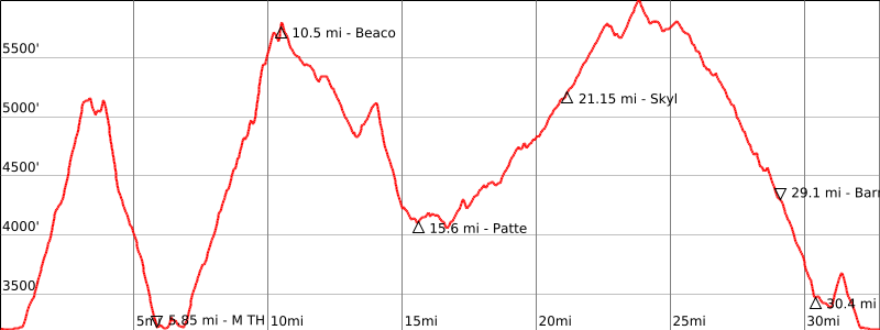
50K course is just under 33 miles in length (yes, that’s closer to 53K) & has nearly 8,000 feet of elevation gain
Course Description: 

- From the start at Dornblaser-Lewis and Clark Stadium, spread out on the dash down South Avenue, then hit the dirt and begin climbing the Fire Road at Maurice Avenue. Continue up the steep pitches of Pengelly Ridge, then cross over to the main summit of Mount Sentinel and make a fast descent on the northwest ridge and M Trail to the parking lot and the first aid station.
- Connect with the Kim Williams Trail, then begin the biggest climb of the race, up the Smokejumper Trail and up University Ridge to the beacon and the second aid station. Wind down the old dirt road on the back of University Mountain the pavilion in the Paee Canyon Picnic Area and the aid station at roughly the halfway point of the race.
- Cross the top of Pattee Canyon Road, and continue down one of the south side trails, then begin climbing again on the Sam Braxton National Recreation Trail, Deer Creek ridge and a short section of dirt road to reach the next aid station at the Skyline Ridge Trailhead. Continue climbing over the House of Sky Trail and Mitten Mountain, past the summit of Mount Dean Stone, then descend the many switchbacks of the High, Wide and Handsome and Woodsy trails to the final aid station at Barmeyer Overlook.
- Descend the Barmeyer Trail and a short stretch of Pattee Canyon Road, then climb from the gas line/gravel pit trailhead back to the Fire Road and return to the finish at Dornblaser via Maurice and South avenues.
Aid Stations:
 Cutoffs:
The course will be open from 7 am to 6 pm, however if runners are not to the following aid station cutoffs, they will be required to drop and driven out by aid station volunteers or course marshals.
- Pattee Canyon Picnic Area aid station (mile 15.5) by 12:45 pm.
- Skyline Ridge Trailhead (mile 21.0) by 2:45 pm,
- Barmeyer Overlook aid station (mile 29.0) by 4:45 pm.
Safety of our participants and volunteers is a top priority and we appreciate your cooperation with this policy. Sweepers will maintain the cutoff pace or remain with the last participant.
Toilets:
Toilets will be available at the start/finish area and at aid stations 1, 3, 4 and 6.
Drop Bags:
Your drop bag will need to be in place at the designated area prior to and near the race start. It will be transported to the Pattee Canyon Picnic Area aid station, approximately halfway through the course. Bags will be returned to the finish line after 3:30 pm.
Splits:
Download 50K Course Maps:
- Download GPX File (updated 03/24/2026)
- Caltopo Map
- Elevation Profile
→ 25K COURSE DETAILS
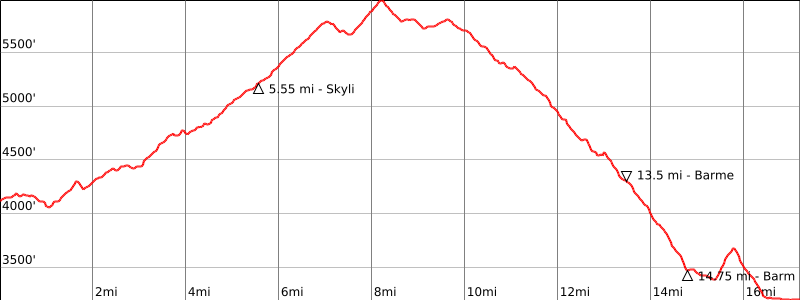
25K is just over 17 miles (see our pattern here) & climbs about 2,700 feet
Course Description: 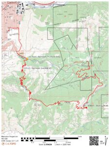

- From the start at the Pattee Canyon Picnic Area pavilion, cross the top of Pattee Canyon Road, and continue down one of the south side trails, then begin climbing again on the Sam Braxton National Recreation Trail, Deer Creek ridge and a short section of dirt road to reach the next aid station at the Skyline Ridge Trailhead. Continue climbing over the House of Sky Trail and Mitten Mountain, past the summit of Mount Dean Stone, then descend the many switchbacks of the High, Wide and Handsome and Woodsy trails to the final aid station at Barmeyer Overlook.
- Descend the Barmeyer Trail and a short stretch of Pattee Canyon Road, then climb from the gas line/gravel pit trailhead back to the Fire Road and return to the finish ta Dornblaser via Maurice and South avenues.
Busing:
25K Participants are required to take provided shuttle bus to the start line. Any participants getting dropped off near the start will have their bib pulled. Buses will load at 7:15 am from the Lewis & Clark Parking Lot. Additional bus load information will be sent in the weeks leading up to the race.
 Aid Stations:
Toilets:
Toilets will be available at the start/finish area and at aid stations 1and 3
Splits:
Download 25K Course Maps:
- Download GPX File (updated 03/24/2026)
- Caltopo Map
- Elevation Profile